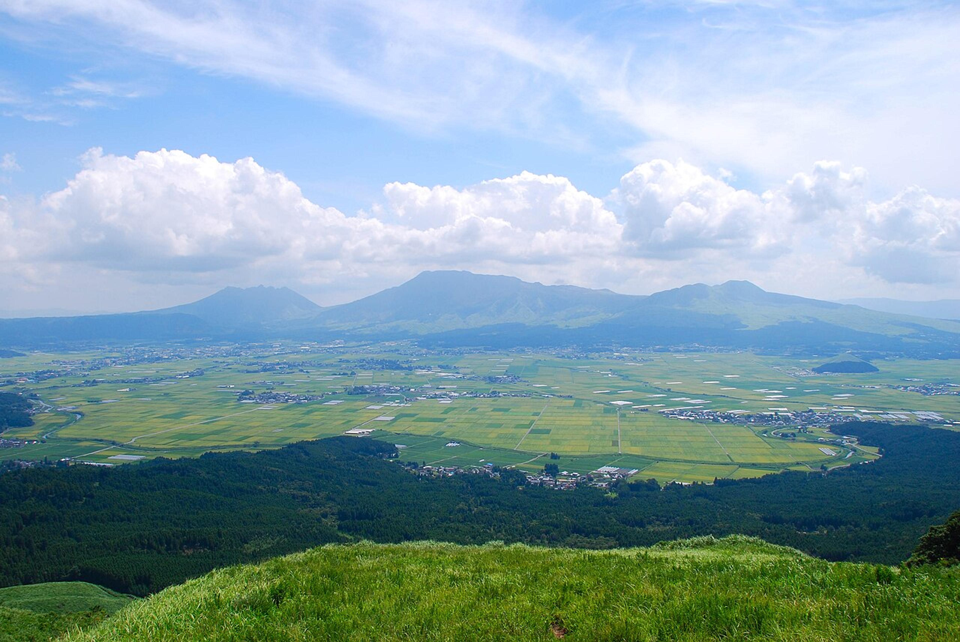
Aso's caldera is 25 km wide, holds seven towns, and has an active crater you can stand beside: grasslands, volcanic lakes, and horseback rides across the rim.
Koku Travel · February 16, 2026
9 places in this guide
The Caldera That Holds a World
Mount Aso's caldera is one of the largest on earth, 25 kilometers north to south, 18 kilometers east to west, with a circumference of over 100 kilometers. The caldera rim rises 300-500 meters above the floor, creating a natural amphitheater so vast that seven towns, 50,000 people, rice paddies, train stations, and a national highway fit comfortably inside. From the rim, the interior looks like a green bowl tilted gently toward the south, with the five peaks of the central Aso-san volcanic group rising from its center like islands from a sea of grass.
The caldera formed approximately 90,000 years ago in a series of four catastrophic eruptions, the largest of which ejected 600 cubic kilometers of material and sent pyroclastic flows racing across most of Kyushu. The scale is almost impossible to process: the eruption was one of the largest volcanic events in the last 100,000 years, and the resulting caldera is now the living room of an entire community. Cows graze on the caldera floor. Children walk to school along roads that follow ancient lava flows. The JR Hohi Line runs a passenger train directly through the breach in the northern rim.
Nakadake: The Active Crater
Nakadake is the active peak of the Aso volcanic group and one of the most accessible active craters in the world. A toll road (¥800 per car) or ropeway-replacement shuttle bus (¥1,200 round trip) climbs to the crater rim, where a concrete observation platform allows visitors to peer directly into the crater lake, a roiling pool of turquoise-gray water heated by magmatic gases. The sulfur smell is sharp and immediate. Steam vents hiss from fractures in the rock. The ground beneath your feet is warm.
The crater access is managed dynamically based on volcanic activity. Gas sensors monitor sulfur dioxide concentrations, and the crater is closed when levels exceed safety thresholds, which happens regularly. The Aso Volcano Museum (¥860), located at Kusasenri below the summit, maintains live camera feeds from inside the crater for days when access is restricted. The museum's exhibits explain Aso's geology with unusual clarity, including a scale model showing how the four mega-eruptions progressively enlarged the caldera.
Nakadake crater access closes frequently due to elevated gas levels. Check the Aso Geopark website or call the Aso Tourism Association (0967-34-1600) before driving up. When open, visitors with respiratory conditions including asthma are advised not to approach. Shelter bunkers line the path, know their locations in case of sudden eruption. This is an active volcano; treat it accordingly.
Kusasenri and the Grassland Plateau
Kusasenri is a broad, flat grassland at approximately 1,100 meters elevation, spread across the saddle between Nakadake and Eboshi-dake. In spring and summer, the grass is a vivid green that contrasts sharply with the gray volcanic peaks above. A shallow rain-fed lake sits in the center of the meadow, reflecting the sky and the volcanic silhouettes. Horses graze freely across the grassland, a scene so pastoral it seems designed to contrast with the violent geology visible in every direction.
Horseback riding across Kusasenri is the signature Aso experience. Several operators offer guided rides ranging from 30-minute loops (¥1,500) to half-day treks (¥8,000) that climb to the Eboshi-dake ridge for panoramic views across the caldera floor to the northern rim. The horses are sturdy Japanese breeds, calm-tempered and sure-footed on the volcanic terrain. Riding across the grassland, with the active crater steaming behind you and the caldera walls encircling the horizon, produces a sensation of inhabiting a vast, improbable geological theater.
Aso's grasslands are maintained by controlled burning (noyaki) every March, a tradition dating back centuries that prevents forest encroachment and renews the soil. The burns are spectacular: lines of fire sweeping across the hillsides, blackening the grass to the roots. Within weeks, fresh green shoots emerge, and by May the grasslands are vivid again. The noyaki schedule is published on the Aso Geopark website.
Daikanbo: The Caldera Rim Panorama
Daikanbo is the premier viewpoint on the northern caldera rim, accessible by car via a winding mountain road from Aso town or from the Yamanami Highway. The observation platform sits at 936 meters and offers a 360-degree panorama that is simply one of the finest views in Japan. To the south, the entire caldera floor spreads below, patchwork rice paddies, clusters of towns, the winding Shira River, and the five central peaks with Nakadake's plume trailing east. To the north, the outer slopes drop away to the Kuju mountain range and the distant peaks of the Aso-Kuju National Park.
On clear days, the view extends to Mount Unzen in Nagasaki Prefecture and the Ariake Sea. The volcanic geography becomes legible from this height: you can trace the caldera rim as a complete circle, identify the breaches where rivers have cut through the wall, and understand how an entire human settlement fits inside a volcanic crater. The effect is both humbling and exhilarating, a reminder that the people of Aso live, by choice, inside one of the most powerful geological formations on the planet.
Daikanbo is best visited in the early morning, when temperature inversions trap fog inside the caldera, creating an unkai (sea of clouds) effect. The central peaks rise above the cloud layer like islands, and the caldera rim appears to float above a white ocean. This phenomenon occurs most frequently from September through November. Check local weather forecasts for low cloud predictions and arrive before 7 AM.
Exploring the Caldera Floor
The caldera floor rewards slow exploration by car or bicycle. Aso Shrine, in the town of Aso, is one of the oldest shrines in Kyushu (traditionally founded 281 BCE) and suffered severe damage in the 2016 Kumamoto earthquakes. The massive two-story romon gate collapsed entirely and has been painstakingly rebuilt, the reconstruction was completed in 2023 using traditional joinery techniques and original timbers where possible. The shrine's festival calendar is active, with the Onda Matsuri rice-planting ceremony (July) featuring elaborately costumed processions through the surrounding paddies.
The caldera's southern floor, around the town of Takamori, is the most agricultural section, rice paddies, vegetable gardens, and cattle ranches spread across the flat terrain. The Takamori Dengaku no Sato restaurant serves irori-grilled dengaku (miso-glazed tofu, vegetables, and river fish cooked on skewers over an open hearth) in a traditional farmhouse setting. A full dengaku course runs ¥1,500-2,500 and is one of the essential Aso food experiences. The local aka-ushi (red beef), raised on caldera grasslands, is prized across Kyushu for its lean, mineral flavor.
The Aso area is exceptionally affordable by Japanese tourism standards. A full day, Nakadake crater bus (¥1,200), Volcano Museum (¥860), Kusasenri horseback ride (¥1,500), Daikanbo parking (free), and dengaku lunch (¥2,000), totals under ¥6,000. Accommodation at local pensions and guesthouses runs ¥5,000-8,000 with breakfast. The JR Hohi Line from Kumamoto to Aso takes 70 minutes and costs ¥1,120.

Turn this guide into a trip
We'll prioritize these 9 places when building your itinerary.